


Land Surveying and Mapping in Finland – Central Finland on the Map
Aalto2, Jyväskylä
- 13.12.2025–10.5.2026
A map does more than indicate location—it reflects society. Throughout history, maps have served as instruments of political power, works of art, conveyors of messages, and symbols of scientific and technological progress. Maps help us navigate the world and understand our environment.
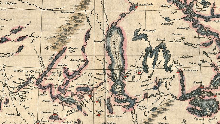
The exhibition “Land Surveying and Mapping in Finland – Central Finland on the Map” presents the 390-year history of land surveying and mapping in Finland. This story began in 1633, when the first surveyor was sent from Sweden to Finland. Over time, the number of surveyors grew, and by the end of the 17th century, almost the entire country had been mapped. The mapping process helped settle land disputes and reduced the violence associated with them.
The large-scale redistribution of farmland, known as the “Great Partition” (or Isojako), began in the late 18th century. This reform brought new work for land surveyors, as the traditional strip-farming system was abolished and fields were redistributed. Forests once held in common by villages were also transferred to private ownership.
The repeated wars during this era highlighted the strategic importance of maps. Finland was mapped successively by Sweden and Russia. For a long time, especially in northern Finland, accurate maps were lacking. This changed with the national base map project (peruskartta), and by 1975, detailed maps covered the entire country.
Struve Geodetic Arc – 20th Anniversary as a UNESCO World Heritage Site
In 1834, globally significant scientific work took place in Central Finland. Survey points of the Struve Geodetic Arc—a chain of triangulation points used to determine the size and shape of the Earth—were measured in several locations: Kuhmoinen, Joutsa, Jämsä, Korpilahti, Jyväskylä, Laukaa, Hankasalmi, Konnevesi, and Saarijärvi. The continuous arc stretched all the way from the Black Sea to the Arctic Ocean.
The Struve Arc was inscribed as a UNESCO World Heritage Site on 18 July 2005. Known as the “measuring tape of the Earth,” it represents cultural heritage in science and technology, and forms a cornerstone of modern mapping. The entire arc is protected, with six representative triangulation points preserved in Finland. In Central Finland, the official point is located at Oravivuori hill in Korpilahti. The exhibition explores the history of the Struve Geodetic Arc and the Oravivuori measurement point in more detail.
The exhibition was curated by Chief Engineer Antti Jakobsson from the National Land Survey of Finland and produced in cooperation with the National Land Survey of Finland and the Museum of Central Finland. It is based on the Land Survey of Finland’s national exhibition “Land Surveying and Mapping in Finland since 1633”. This local version has been adapted to include the Struve Arc and additional historical maps specific to Central Finland.
Share this with your friends!
Museum exhibitions
- Marie-José Van Hee – For Sun and Wind to Paint on
25.9.2025 - 12.4.2026 - COLOUR – Highlights from the Art Collections of Central Finland
24.1.2026 - 26.4.2026 - Land Surveying and Mapping in Finland – Central Finland on the Map
13.12.2025 - 10.5.2026 - Freddy Fabris: The Renaissance Series
13.6.2026 - 27.9.2026 - Rally Finland – 75 Years of Gravel, Heroes, and a Travelling Circus
13.6.2026 - 8.11.2026 - 13 Stories about Humane Design
24.4.2026 - 10.1.2027 - Architecture of Light
22.11.2026 - 14.3.2027 - The Contemplative Eye of Jonas Heiska – Quiet Poetics, Warm Humour
10.10.2026 - 10.10.2027 - Exploring Central Finland
22.2.2020 - 1.1.2050 - AALTO – Work and Life
27.5.2023 - 1.1.2050
Museum events
Osana kulttuurikierrosta
Museum contact details
![]()
Aalto2
Alvar Aallon katu 7, 40600 Jyväskylä
+358 44 790 9827
Yhteydet julkisilla
Näytä reitti museolle Matkahuollon reittioppaassa
Katso reitti Matkahuollon reittioppaassa
Päämäärä:
Aalto2, Alvar Aallon katu 7, 40600 Jyväskylä
Lähtöpiste:
Admission fees

18/15/10/4/0€
Payment methods
Korttimaksu ja käteinen.
Card payments and cash.
Opening hours
| Mon | Closed |
| Tue | 11:00-18:00 |
| Wed | 11:00-18:00 |
| Thu | 11:00-18:00 |
| Fri | 11:00-18:00 |
| Sat | 11:00-18:00 |
| Sun | 11:00-18:00 |
+358 44 790 9827